|
Glasbury Settlement to 1750 Clwyd Powys Archaeological Trust Historic Settlements Survey - Radnorshire |
|
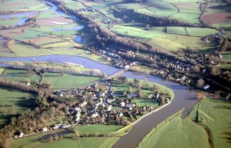
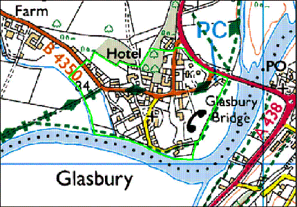
Glasbury SO 176391 16144 Introduction
Glasbury now lies just off the A438 Hereford to Brecon road, while
the B4350 passes through the village. Hay-on-Wye (Brecknock) is
6km to the north-east. Linked by Glasbury Bridge, the settlement
is in two parts. The historic core is in Radnorshire, with a more
modern extension on the south bank of the Wye in what was Brecknock
Borough. It is an unusual settlement in that it is located on
the valley floor, with the hills nearly one kilometre to the north-west:
the settlement lies against the river, a stone wall on the south
side and an earthwork flood barrier in fields on the west protecting
the village. This brief report examines Glasbury’s emergence
and development up to 1750. For the more recent history of the
settlement, it will be necessary to look at other sources of information
and particularly at the origins and nature of the buildings within
it. The accompanying map is offered as an indicative guide to
the historic settlement. The continuous line defining the historic
core offers a visual interpretation of the area within |
|
|
|
|
|
History of development The earliest form of the name is Clastbyrig, recorded in 1056 incorporating the Old Welsh clas meaning a monastic community and Old English burh, signifying a defended enclosure. In the 16th century, its Welsh name was y Klas ar Wy, or the clas on the Wye. In the absence of any evidence to the contrary, it has to be assumed that the clas community occupied a site that gave them some protection, perhaps from human aggressors though possibly from the river. The 'clas' foundation (516) is reputed to have been established in the 7th century AD by St Cynidr, and a tradition evolved that this was on Ffynnon Gynydd common some 2.5km northnorth- west of the village, largely because this is the location for St Cynidr’s well, and this tradition then became fact. In fact the clas was almost certainly on the valley floor where the earthworks of it or its successor can still be observed, though the shifting course of the river means the site is now on the south of the river and divorced from Glasbury itself. The manor of Glasbury was granted to St Peter's, Gloucester in 1056, providing the explanation for the church's dedication. Soon after the Norman Conquest in 1090 a new church was built on the site of the clas beside the River Wye. During the Middle Ages a nucleated settlement emerged at Glasbury, more perhaps because there was a crossing point of the river here than because of the long ecclesiastical history. An estate map of 1753 depicts a village with well-spaced dwellings, nearly a dozen in all, and a green, encroached on by three cottages in the centre. Some elements of this pattern are certainly medieval. By this date a stone bridge had replaced the wooden one which was destroyed in 1738. The church was abandoned during the 17th century when the river’s course changed and more than a century later the configuration was disrupted by the construction of Glasbury House. At least two houses were removed to make way for the house, others may have disappeared in the landscaping, and a road leading to the river was abandoned. The Green is an appellation still attached to an area within the village, rather smaller than its medieval predecessor. A century later, the Tithe survey reveals the infilling of open spaces within the village and some expansion north-west towards Cwmbach. In summary, Glasbury could have developed as a common or green-side settlement in the Middle Ages. Although only two pre-18th-century dwellings remain, others are likely to have existed around the open common and on the lanes approaching it. The Heritage to 1750 The site of the early church, now in Brecknock and lying at the
confluence of the Wye and the Llynfi shows as earthworks; a raised
platform with the foundations of the medieval church on it has
a curvilinear enclosure attached to it. A full survey was undertaken
by CPAT and is published in the county society transactions for
2003. The present church of All Saints was built in Cwmbach less
than a mile to the north-west in 1882, upon the establishment
of the ecclesiastical parish of Glasbury in Radnorshire. A motte
and probable bailey (517) lay a little but further back from the
river. Nothing is known of its history and several different dates
have been suggested for its construction, Glasbury Old Vicarage (524; Grade II* listing) originated as
a medieval stone dwelling, sometime after 1400, and has been identified
as a pre-Reformation priest's house. Though modernised, some Tudor
work is preserved on the north-west and there is an inscription
of 1611 on the chimney. Next to the Old Vicarage is a barn of
cruck construction (16017; Grade II* listing), perhaps for vicarial
tithes and considered to be of 15th-century origin. The Forge
is a stone-built cross-passage house of c.1600. No other listed
buildings in the village are known to pre-date the late 18th century,
though Grangeton (36567) is thought to have had earlier origins
because of its gable-end position to the lane. |